Cyclone Gretel tipped to form off coast tonight, move further away
A deepening low moving into the Coral Sea is expected to continue to move away from Queensland as it potentially strengthens into a category one cyclone, easing severe weather conditions on the coast.
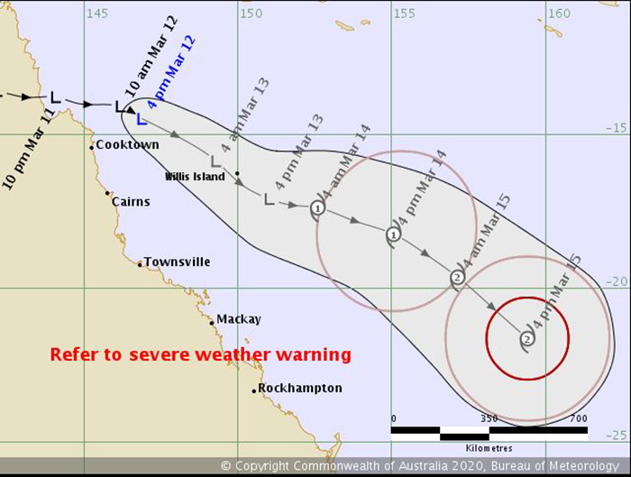
The tropical low is currently north-east of Cooktown and is expected to continue to move south-east and strengthen into a category one cyclone about 10:00pm on Friday.
If it does form, it will be called Gretel.
Bureau of Meteorology (BOM) forecaster Rosa Hoff said severe weather over the central and north Queensland coasts would ease.

“As the system moves away from the Queensland coast, the weather we’re seeing will actually ease back even though the cyclone will intensify,” Ms Hoff said.
“So far exposed parts of the coastline have experienced the heavier rainfall and particularly those damaging wind gusts.
“But as the system continues to track towards the south east and away from Queensland’s coast, we will see those effects easing.”
A wind gust of 87 kph was recorded at Hamilton Island on Thursday.
Tully had more than 190 millimetres of rain in the 24 hours to 9:00am Thursday, while Innisfail Aerodrome recorded 155 mm.
Stay informed, daily
“Strong winds will continue to be a concern for the coming days with gale wind warnings issued,” Ms Hoff said.
“We do have a flood watch current from the Cape York Peninsula, all the way down to Ingham.
“It’s likely we could see some flash flooding about parts … generally though as activity eases with the system moving away, we’re not expecting to see a drastic increase in flood waters.”
– ABC / Ash Stevenson
Want to see more stories from InDaily Qld in your Google search results?
- Click here to set InDaily Qld as a preferred source.
- Tick the box next to "InDaily Qld". That's it.